Issue #10, Doubtful Sound and Manapouri Hydro Power Station
April 24--27, 2013
 |
| Fiordlands National Park. Credit: NZ Dept. of Conservation |
After Dunedin, we went to Doubtful Sound, in the Fiordlands, and the Manapouri Hydroelectric Power Station, in the far southwest corner of the South Island. This part of the trip was perhaps the most extraordinary of all; but it almost didn’t happen.
Itinerary, in brief:
Wed. April 24: Dunedin on the SE coast to Manapouri: a gateway to the Fiordlands.
Thursday April 25: Manapouri to ferry across Lake Manapouri to bus over Wilmot Pass down to Doubtful Sound to ship. Spent night aboard ship.
Friday, April 26: Ship to shore to bus back over Wilmot Pass to power station; amazing private tour of the power station at end of the public tour; to ferry back across Lake Manapouri to Manapouri to get car; then drive to Te Anau for night. Amazing movie that evening.
Wed. April 24: Dunedin on the SE coast to Manapouri, a gateway to the Fiordlands on the SW coast.
In Dunedin it continued to rain. We’d planned to drive northwest from Dunedin to the heart of the New Zealand Alps, probably to the Aoraki/Mount Cook area for a day or two, before heading north back to the ferry and the North Island. This is probably the most famous of all the spectacular parts of the South Island, and was to be the highlight of our South Island trip. We cancelled. Rain was forecast for the next week (accurately, as it turned out), and we realized there was no point in going to see mountains that we wouldn’t be able to see. (Duh.) We resigned ourselves to trudging back the way we’d come, driving back SH1 all the way north to the Cook Strait ferry.
BUT: A person who interviewed Mike on the morning of our departure from Dunedin changed our minds. Like almost every Kiwi we talked to, she was eager to hear about our travel plans, and delighted to give suggestions and advice re her own special places that we should not miss. Hers was Doubtful Sound, and she argued convincingly. Here we were almost at the south end of the South Island, not all that far from Fiordlands National Park on the southwest coast--just a hop, skip and a jump over a few mountain ranges and across a couple of lakes. Sure, it would take three or four extra days, but to get Mike back to Hamilton in time for next week’s lecture, we could grab a flight for him from Queenstown (via New Zealand’s great Grab-a-seat website), and then Loring could drive the car back at her leisure. No worries, mate. Brilliant.
When we diffidently brought up the weather forecast, she pointed out that the weather in the Fiordlands was almost always rainy anyway, so that wasn’t a problem. And we were so near. We SHOULD NOT miss the Fiordlands.
So, that’s what we did. And she was right on both counts. It rained, and Doubtful Sound was extraordinary. (Here the blogger skips tactfully over our marriage’s extended discussion re whether this new idea was an opportunity not to be missed, or insane.)
Visiting Doubtful Sound is a snap. All you have to do is book the Lake Manapouri ferry, the bus over Wilmot Pass, the Doubtful Sound ship, the Wilmot pass bus and Lake Manapouri Ferry on the way back, and find places to stay for both ends of the adventure. Correct: “You can’t get there from here”. Oh, plus get Mike’s flight, sketch out Loring’s drive back north the length of the South Island, cancel Mike’s Cook Strait Ferry reservation, and change Loring’s. After an online and phone flurry of bookings, we grabbed our gear, loaded the car, and headed yet further south--priding ourselves on our new Alfred E. Newman approach to scheduling. No worries.
 |
| View from our backpacker in Manapouri. LS improved the view, and got a gardening fix, by volunteering to prune the shrubs around the house. |
On our drive to Manapouri, the weather improved for a bit. We saw mountains! And the tops of mountains! And more than one mountain! Fascinating folks at the backpacker that evening: a French Woofer (Willing Workers on Organic Farms) plus his visiting mom, an Australian couple, and an American from California who was bicycling all around the South Island (and we thought that DRIVING on these roads in the rain was tough...).
Thursday, April 25
On board the Fiordland Navigator on Doubtful Sound.
This is a more typical view of the Sound:
“Fiordland National Park occupies the southwest corner of the South Island of New Zealand. It is the largest of the 14 national parks in New Zealand, with an area of 12,500 km², and a major part of the Te Wahipounamu World Heritage site ... Doubtful Sound is a very large and naturally imposing fiord in Fiordland ... It is located in the same region as the smaller but more famous and accessible Milford Sound.
 |
| This is our ship, and this is Doubtful Sound. But how come all the website PR photos show sun, when it rains there 200 days a year? Photo credit: Realjourneys. |
 |
| Photo credit: Wiki |
“Access to the sound is either by sea, or by the Wilmot Pass road from the Manapouri Power Station [which itself is accessible from the rest of NZ only by boat across Lake Manapouri. --LS] Most areas of the sound itself are only accessible by sea however, as the road network in this area of New Zealand is sparse or nonexistent, as is the human population.” --Wikipedia
"At 421 metres, Doubtful Sound is the deepest of New Zealand’s fiords. It’s a haven for nature, with resident bottlenose dolphins, fur seals and penguins." --NZ DOC
Note: 421 meters is 1,381 feet. This is DEEP. And Lake Manapouri is 1,457 feet deep. This is REALLY DEEP. "Lake Manapouri was formed by glaciers during the last Holocene. The lake is New Zealand’s second deepest lake measuring 444 metres (1,457 ft) deep. Lake Manapouri is 178 metres (584 ft) above sea level; however due to glaciers, Lake Manapouri has been cut deep into the ground and the bottom of the lake now lies 267 metres (876 ft) below sea level." --Wiki
 |
| Ferry and landing on lake: the boat to nowhere |
 |
| Mountains around Lake Manapouri, from the ferry |
The ferry was packed, mostly with folks bound, like us, for the overnight cruise on Doubtful Sound, plus a few day trippers.
At the head of Lake Manapouri is the power station. Land access to Doubtful Sound exists because of the power station: the road over the pass from the station to the sound was created to build the power station. More on that later. At the power station visitor center, we all transferred to the bus over Wilmot Pass. It was pouring rain (natch), and waterfalls cascaded down the steep hills along the road.
At the head of Lake Manapouri is the power station. Land access to Doubtful Sound exists because of the power station: the road over the pass from the station to the sound was created to build the power station. More on that later. At the power station visitor center, we all transferred to the bus over Wilmot Pass. It was pouring rain (natch), and waterfalls cascaded down the steep hills along the road.
 |
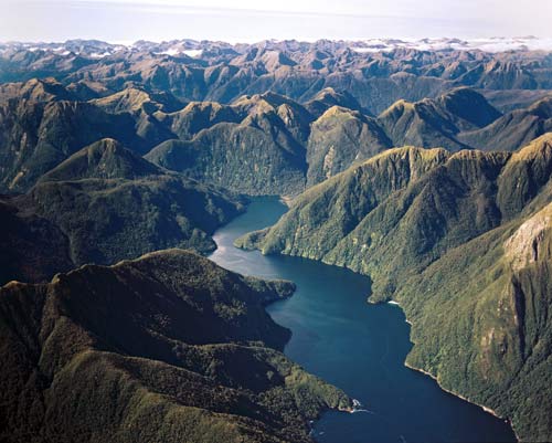
| Deep Cove of Doubtful Sound, from above. Photo Credit: Wiki |
“Charles John Lyttelton, 10th Viscount Cobham, Governor-General of New Zealand (from 1957–1962) wrote about this part of Fiordland:
'There are just a few areas left in the world where no human has ever set foot. That one of them should be in a country so civilized and so advanced as New Zealand may seem incredible, unless one has visited the south-west corner of the South Island. Jagged razor -backed mountains rear their heads into the sky. More than 200 days of rain a year ensure not a tree branch is left bare and brown, moss and epiphytes drape every nook. The forest is intensely green. This is big country... one day peaceful, a study in green and blue, the next melancholy and misty, with low cloud veiling the tops... an awesome place, with its granite precipices, its hanging valleys, its earthquake faults and its thundering cascades.'" --also from the Wiki article.
Clearly Viscount Cobham loved the area, and could write about it beautifully.
It is remote, and spectacular. You can hire a kayak tour, or take an overnight cruise ship.
Clearly Viscount Cobham loved the area, and could write about it beautifully.
It is remote, and spectacular. You can hire a kayak tour, or take an overnight cruise ship.
 |
| One of many waterfalls on Lake Manapouri |
 |
| On board the ship in Doubtful Sound |
 |
| Our comfy room on the ship |
 |
| On the bridge. Please note the tea cozy and the captain's cuppa tea. |
The ship carries kayaks and small tour dinghies. Before supper, dodging rain showers, they got a bunch of us out on the water in kayaks. What a slick operation. They got over twenty boats, with all of us equipped with lifejackets and paddles, on the water in about twenty minutes. We paddled about in the dusk and drizzle, up little tributaries, under waterfalls, and under low-hanging shrubbery on the cliff edges. I wish we had a photo of the mother ship, with all its lights shining, and all the little kayaks homing in as dark fell. But I've lost the e-mail of the guy who was taking photos with his waterproof camera.
 |
| At the bow of the ship--close to a seal rock |
Friday April 26: On board ship, then back to the power station and back to Manapouri.
We cruised through the various arms of Doubtful Sound--any one of which could fit the more famous, but smaller, Milford Sound. Waterfalls, waterfalls, waterfalls. Never seen the like. Unlike Milford Sound, which has the dubious distinction of being the wettest place in NZ, Doubtful Sound gets a mere three feet of rain per year. THREE FEET. (Montpelier's average, for rainfall plus snowfall, is 37 inches.) Some of the waterfalls cascade over 600 meters (almost 2,000 feet.) You are at sea level, and some of the peaks surrounding the sound are almost 4,600 feet high. That's right: 4,600 feet of vertical rise, right over your head.We saw fur seals, and thanks to the squally weather, albatrosses, plus various other sea birds. (Please stay tuned for LS' NZ bird blog post.)
On the way back to Manapouri, after returning over the pass, we had a tour of:
Manapouri Hydroelectric Power Station
 |
| Display at the visitors' center |
 |
| This is the power station's water intake and switchyard. From here, huge groups of power lines head out to the South Island. |
 |
| A nifty1:1600 scale model of the Manapouri Power Station, showing the pipes (blue) which transport water from the lake to the generators, and the vehicle tunnel (yellow) accessing the turbine hall. Our bus drove all the way down the tunnel. Model by Meridian Energy; photo credit: Wiki. Or maybe Meridian. Whatever. |
.jpg) |
| The tunnel leading down to the power station. Photo credit: Wiki |
 |
| The turbine room |
Oh, what an adventure.


